viktor.geo
RobertsonMethod
- class viktor.geo.RobertsonMethod(soil_properties)
Bases:
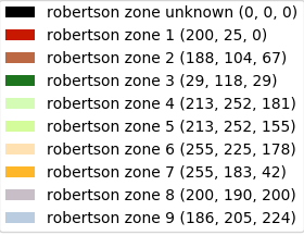
_ClassificationMethodClass to pass Robertson specific properties such as soil_properties. Every list element at least requires a ‘name’ key that specifies the RobertsonZone. It is important that ‘name’ key matches with hardcoded RobertsonZone.name property. There are 9 Robertson zones and 1 Robertson zone unknown that can be specified
By default, the colors as defined in (red, green, blue) for each zone are as shown in this figure:
Example:
soil_properties = [ {'name': 'Robertson zone unknown', 'extra_property1': 1, 'extra_property2': 2}, {'name': 'Robertson zone 1', 'extra_property1': 3, 'extra_property2': 4}, ] method = RobertsonMethod(soil_properties)- Parameters
soil_properties (
List[dict]) – dictionary with soil properties
- get_method_params()
- Return type
dict
TableMethod
- class viktor.geo.TableMethod(qualification_table, ground_water_level)
Bases:
_ClassificationMethodClass to pass TableMethod specific properties, such as a qualification_table and ground_water_level. The qualification_table is a list of dictionaries, containing for each user-specified soil type the accompanying qualification parameters (and possibly additional material properties). The required fields for each row are:
name
color in r, g, b
Also required fields, but can also be (partly) empty:
qc_min
qc_max
qc_norm_min
qc_norm_max
rf_min
rf_max
gamma_dry_min
gamma_dry_max
gamma_wet_min
gamma_wet_max
For more information about qc_norm (qc_normalized), see table 2.b in in NEN 9997-1+C1:2012, point g specifically. Besides the qualification table, a ground_water_level has to be provided as well, which is used to determine if gamma_dry or gamma_wet should be used to calculate qc_norm for each entry in the GEF file.
Example:
qualification_table = [ {'name': 'Peat', 'color': '166,42,42', 'qc_min': 0, 'qc_max': '', 'qc_norm_min': '', 'qc_norm_max': '', 'rf_min': 8, 'rf_max': '', 'gamma_dry_min': 10, 'gamma_wet_min': 10, <OTHER>}, {'name': 'Clay', 'color': '125,180,116', 'qc_min': '', 'qc_max': 2, 'qc_norm_min': '', 'qc_norm_max': '', 'rf_min': 1, 'rf_max': 8, 'gamma_dry_min': 20, 'gamma_wet_min': 22, <OTHER>}, {'name': 'Loam', 'color': '125,150,116', 'qc_min': 2, 'qc_max': '', 'qc_norm_min': '', 'qc_norm_max': '', 'rf_min': 1, 'rf_max': 8, 'gamma_dry_min': 20, 'gamma_wet_min': 22, <OTHER>}, {'name': 'Sand', 'color': '239,255,12', 'qc_min': '', 'qc_max': '', 'qc_norm_min': 22, 'qc_norm_max': '', 'rf_min': 0, 'rf_max': 1, 'gamma_dry_min': 24, 'gamma_wet_min': 26, <OTHER>}, {'name': 'Gravel', 'color': '255,255,128', 'qc_min': '', 'qc_max': '', 'qc_norm_min': '', 'qc_norm_max': 22, 'rf_min': 0, 'rf_max': 1, 'gamma_dry_min': 24, 'gamma_wet_min': 26, <OTHER>} ] ground_water_level = -4.63 method = TableMethod(qualification_table, ground_water_level)- Parameters
ground_water_level (
float) – Ground water level is used to compute qc_norm using either gamma_dry or gamma_wetqualification_table (
List[dict]) – List containing rows defining a soil
- get_qualification_table_plot(fileformat)
Use this method to obtain a plot of the qualification table. On the x axis the Rf values are plotted, on the y axis Qc values are shown. Each line, representing a soil, is shown as an area in this plot. This allows for easy inspection of the qualification rules, showing areas of the plot that might still be empty, or soil areas that overlap (in which case the area on top will be chosen). Use the fileformat argument to specify if the result should be a BytesIO containing pdf or png bytes or a StringIO containing svg data
- Parameters
fileformat (
str) – specify if required fileformat is pdf, png or svg- Return type
Union[BytesIO,StringIO]- Returns
qualification table plot as either BytesIO (‘pdf’ or ‘png’) or StringIO (‘svg’) object
- get_method_params()
- Return type
dict
NormalizedSoilBehaviourTypeIndexMethod
- class viktor.geo.NormalizedSoilBehaviourTypeIndexMethod(ic_table, ground_water_level, specific_weight_soil, resolution=None)
Bases:
_ClassificationMethodClass to classify soil based on the normalized soil behaviour type index
Example:
ic_table = [
   {'name': 'Sand', 'color': '0, 50, 255', 'ic_min': 0, 'ic_max': 3.5},
   {'name': 'Clay', 'color': '80, 70, 25', 'ic_min': 3.5, 'cone_factor': 20},
]

ground_water_level = 0
specific_weight_soil = 17
method = NormalizedSoilBehaviourTypeIndexMethod(ic_table, ground_water_level, specific_weight_soil)
This method uses the assumption that the specific weight of all the soil layers is the same, this is a simplification. It is possible to calculate the specific weight from qc values.
- Parameters
ic_table (
List[dict]) – Table with soil types that correspond to Ic values. Keys: name, ic_min, ic_max, color, cone_factorground_water_level (
float) – Ground water level used to compute qc_normspecific_weight_soil (
float) – Specific weight of soil in kN/m^3 used to calculate sigma’resolution (
Optional[float]) – Resolution of the classification in m; if None classify each line of data
- get_method_params()
- Return type
dict
GEFData
- class viktor.geo.GEFData(gef_dict)
-
Initialize GEFData object to simplify working with GEF data. Every GEF has different header fields, and therefore only a limited amount of fields is compulsory. All other header fields are also added as attribute. Compulsory header fields are:
name
ground_level_wrt_reference
Other header fields might be compulsory for methods on the object (e.g. get_cone_visualization). See docstring of the specific method for needed headers.
The following measurement_data fields are also compulsory and are implicitly parsed from the file (do NOT need to be specified explicitly):
elevation
qc
Rf
Examples of optional attributes from header are:
height_system
project_name
project_id
gef_file_date
gef_version_number
x_y_coordinates
coordinate_system
excavation_depth
measurement_standard
surface_area_quotient_tip
water_level
cone_tip_area
cone_type
Measurement_data fields that are optional are:
u2
fs
penetration_length
corrected_depth
inclination
inclination_n_s
inclination_e_w
Example implementation to create GEFData object:
from viktor.core import ViktorController, ParamsFromFile from viktor.geo import GEFFile, GEFData class GEFFileController(ViktorController): ... @ParamsFromFile(file_types=['.gef']) def process_file(self, file, **kwargs) -> dict: file_content = file.getvalue(encoding="ISO-8859-1") gef_file = GEFFile(file_content) gef_data_object = gef_file.parse(additional_columns=['elevation', 'qc', 'Rf', 'fs', 'u2'], return_gef_data_obj=True) gef_dict = gef_data_object.serialize() return {'gef_dict': gef_dict} def get_gef_content_from_database(self) -> GEFData: # API call to right entity return GEFData(gef_file_entity.last_saved_params['gef_dict'])- Parameters
gef_dict (
Union[dict,Munch]) – dictionary with [‘headers’] and [‘measurement_data’] keys
- classify(method, return_soil_layout_obj=True)
Create SoilLayout object or dictionary by classifying the GEF measurement data, using either the Robertson method or a qualification table method.
RobertsonMethod
This method requires the GEFData object to at least contain the measurement data ‘corrected_depth’. See
GEFDatafor all possible measurement data columns.from viktor.geo import RobertsonMethod soil_properties = [ {'name': 'Robertson zone unknown', 'extra_property1': 1, 'extra_property2': 2}, {'name': 'Robertson zone 1', 'extra_property1': 3, 'extra_property2': 4}, ] classification_method = RobertsonMethod(soil_properties) soil_layout_dict = gef_data.classify(method=classification_method, return_soil_layout_obj=False)TableMethod
For this method a qualification table has to be provided by the user, for example through a VIKTOR editor. Please refer to the docstring of
TableMethodfor the structure of this table.This table is usually controlled on a project-wide level, so in a parent entity. On the controller of the GEF file, you can use the API to retrieve the table content and pass it to the TableMethod:
from viktor.api_v1 import API

api = API()
parent_entity = api.get_entity(entity_id).parent()
parent_params = parent.last_saved_params
qualification_table = parent_params['material_properties']
ground_water_level = parent_params['ground_water_level']

classification_method = TableMethod(qualification_table, ground_water_level)
soil_layout_obj = gef_data.classify(method=classification_method, return_soil_layout_obj=False)
Note
This method needs to be mocked in (automated) unit and integration tests.
- Parameters
method (
_ClassificationMethod) – Specifies which method should be used for qualification: TableMethod | RobertsonMethod | NormalizedSoilBehaviourTypeIndexMethod.return_soil_layout_obj (
bool) – Flag to return SoilLayout object or dictionary
- Return type
Union[dict,SoilLayout]- Returns
SoilLayout object or dictionary (=SoilLayout.serialize())
- serialize()
- Return type
Union[dict,Munch]
- get_cone_visualization(axes)
Modify (clean/empty) ‘axes’ input argument to plot cone resistance (with pore pressure if present in GEF data).
- Parameters
axes (
Axes) – Axes object that will be modified.
The following header fields are compulsory and need to be specified when the GEFData object is created:
max_measurement_depth_wrt_reference
ground_level_wrt_reference
height_system
Example usage:
import matplotlib.pyplot as plt # Create main figure fig = plt.figure(figsize=(8.27, 11.69)) # Define contour (rectangle) for cone visualization, and create Axes object that can be modified by # functions rect_cone = [0.1, 0.1, 0.4, 0.9] # [left, bottom, width, height] cone_axes = plt.axes(rect_cone) # Modify created Axes objects self.gef_data.get_cone_visualization(cone_axes) # Convert to SVG for visualization svg_data = StringIO() fig.savefig(svg_data, format='svg', bbox_inches='tight', pad_inches=0.8) plt.close() gef_visualisation_data = svg_data.getvalue()- Return type
None
- get_resistance_visualization(axes)
Modify (clean/empty) ‘axes’ input argument to plot resistance number.
- Parameters
axes (
Axes) – Axes object that will be modified.
The following header fields are compulsory and need to be specified when the GEFData object is created:
max_measurement_depth_wrt_reference
ground_level_wrt_reference
Example usage:
import matplotlib.pyplot as plt # Create main figure fig = plt.figure(figsize=(8.27, 11.69)) # Define contour (rectangle) for resistance number visualization, and create Axes object that can be # modified by functions rect_resistance = [0.1, 0.1, 0.4, 0.9] # [left, bottom, width, height] resistance_axes = plt.axes(rect_resistance) # Modify created Axes objects self.gef_data.get_resistance_visualization(resistance_axes) # Convert to SVG for visualization svg_data = StringIO() fig.savefig(svg_data, format='svg', bbox_inches='tight', pad_inches=0.8) plt.close() gef_visualisation_data = svg_data.getvalue()- Return type
None
- get_plotted_denotation_large_qc_values(axes, x_loc_text)
Can be used to add text labels with the maximum qc value of a layer that exceeds the maximum value of the x-axis.
- Parameters
axes (
Axes) – Axes object that will be modified.x_loc_text (
float) – Maximum qc value.
The following header fields are compulsory and need to be specified when the GEFData object is created:
max_measurement_depth_wrt_reference
An example is shown below where the figure is capped at a maximum qc of 30 MPa (hence x_loc_text=30).

- Return type
None
GEFFile
- class viktor.geo.GEFFile(file_content)
-
- parse(additional_columns=None, verbose=True, return_gef_data_obj=True)
Parse GEFFile, and return information from GEF in dict with [‘headers’] and [‘measurement data’] sub-dicts or a GEFData object.
Example implementation:
from viktor.core import ViktorController, ParamsFromFile
from viktor.geo import GEFFile, GEFData


class GEFFileController(ViktorController):
    ...

    @ParamsFromFile(file_types=['.gef'])
    def process_file(self, file, **kwargs) -> dict:
        file_content = file.getvalue(encoding="ISO-8859-1")
        gef_file = GEFFile(file_content)
        gef_data_obj = gef_file.parse(additional_columns=['fs', 'u2'], return_gef_data_obj=True)

        soil_properties = [
            {'name': Robertson zone unknown, 'extra_property1': 1, 'extra_property2': 2},
            {'name': Robertson zone 1, 'extra_property1': 3, 'extra_property2': 4},
        ]

        soil_layout_dict = gef_data_obj.classify(method=RobertsonMethod(soil_properties), return_soil_layout_obj=False)
        parsed_dict = gef_data_obj.serialize()
        parsed_dict['soils'] = soil_layout_dict
        return parsed_dict
Note
This method needs to be mocked in (automated) unit and integration tests.
- Parameters
additional_columns (
Optional[List[str]]) –In order for a GEF file to be of use in VIKTOR, three columns are required:
elevation (corrected depth with respect to a specified datum)
qc (tip pressure as measured)
Rf (friction number, either measured or computed using qc and fs)
These three columns will always be parsed and returned, additional columns can be parsed as well. Possible columns to request are:
”penetration_length”
”corrected_depth”
”fs”
”u2” (for more accuracy when qualifying layers using Robertson method)
”inclination”
”inclination_n_s”
”inclination_e_w”
verbose (
bool) – Boolean specifying if parsing should output warnings or work in silencereturn_gef_data_obj (
bool) – Boolean to return GEFData or dictionary
- Return type
Union[dict,GEFData]- Returns
dictionary with GEF parameters or GEFData object with GEF parameters as attributes
gef_visualization
- viktor.geo.gef_visualization(gef_data, soil_layout_original, soil_layout_user, *, as_file=False)
Standard visualization for GEF File.
Example usage:
class Controller(ViktorController): ... @ImageView("GEF plot", duration_guess=2) def visualize(self, params, **kwargs): gef_data = ... soil_layout_original = ... soil_layout_user = ... svg_image = gef_visualization(gef_data, soil_layout_original, soil_layout_user) return ImageResult(svg_image)- Parameters
gef_data (
GEFData) – GEFData object to be visualizedsoil_layout_original (
SoilLayout) – SoilLayout from GEFData. Layers must be sorted from top to bottom.soil_layout_user (
SoilLayout) – SoilLayout that is filtered/modified by user. Layers must be sorted from top to bottom.as_file (
bool) – return as str (default) or FileNew in v13.5.0
- Return type
Union[str,File]- Returns
SVG image file
Soil
- class viktor.geo.Soil(name, color, properties=None)
-
Set name and color of Soil material. Extra properties can be added with dictionary, and keys are added as attribute via ‘munchify’. They are accessible as self.properties.{extra_property_name}
- Parameters
name (
str) –color (
Color) – color of soil used in plotsproperties (
Union[dict,Munch,None]) – dict with optional extra parameters to be added to Soil
- update_properties(properties)
Replace the current properties dict with the provided new one.
For backwards compatibility, this function is kept with this functionality. In order to be able to update the existing properties dict, the properties property is public and mutable.
- Parameters
properties (
Union[dict,Munch]) – dictionary with all SoilLayer properties- Return type
None
- serialize()
Serialize Soil in following dictionary structure:
{ 'name', 'color', 'properties': { (..extra_properties..) }, }- Return type
dict- Returns
dictionary with all properties of Soil
UndefinedSoil
- class viktor.geo.UndefinedSoil
Bases:
SoilSet name and color of Soil material. Extra properties can be added with dictionary, and keys are added as attribute via ‘munchify’. They are accessible as self.properties.{extra_property_name}
- Parameters
name –
color – color of soil used in plots
properties – dict with optional extra parameters to be added to Soil
PiezoLine
- class viktor.geo.PiezoLine(points, phreatic=False)
Bases:
PolylineClass to represent a Piezo line.
Essentially, this is a polyline with a flag added to mark the phreatic polyline.
- Parameters
points (
List[Point]) – points of the polylinephreatic (
bool) – mark the phreatic waterline
- serialize()
Return a json serializable dict of form:
[ {'x': point_1.x, 'y': point_1.y}, {'x': point_2.x, 'y': point_2.y} ]- Return type
dict
SoilLayer
- class viktor.geo.SoilLayer(soil, top_of_layer, bottom_of_layer, properties=None)
-
Create a SoilLayer to be used in SoilLayout
- Parameters
soil (
Soil) – Type of soiltop_of_layer (
float) – Top of layerbottom_of_layer (
float) – Bottom of layerproperties (
Union[dict,Munch,None]) – dict with optional extra parameters to be added to SoilLayer
- property thickness: float
- Return type
float
- serialize()
Serialize SoilLayer in following dictionary structure:
{ 'soil', 'top_of_layer', 'bottom_of_layer', }- Return type
dict- Returns
dictionary with properties of SoilLayer
- update_soil_properties(properties)
- Return type
None
- update_properties(properties)
Replace the current properties dict with the provided new one.
For backwards compatibility, this function is kept with this functionality. In order to be able to update the existing properties dict, the properties property is public and mutable.
- Parameters
properties (
Union[dict,Munch]) – dictionary with all SoilLayer properties- Return type
None
SoilLayer2D
- class viktor.geo.SoilLayer2D(soil, top_profile, bottom_profile, properties=None, piezo_line_top=None, piezo_line_bottom=None)
-
A 2D representation of a soil layer
A Soil layer 2d always consists of a soil and a top and bottom profile Optionally, properties and top and bottom pl lines can be added
Top and bottom profiles need to be monotonic ascending in x-direction Top and bottom profiles need to have identical start x and end x coordinates. These will become the left and right boundaries
Top and bottom profiles can overlap, but not intersect. The layer can have one or multiple ranges with zero thickness, but the top profile may never lie below the bottom profile
- Parameters
- serialize()
Serialize SoilLayer in following dictionary structure:
{ 'soil': Soil 'top_profile': Polyline 'bottom_profile': Polyline 'piezo_line_top': serialized PiezoLine 'piezo_line_bottom': serialized PiezoLine 'properties': Dict }- Return type
dict- Returns
dictionary with properties of SoilLayer
- classmethod from_dict(soil_layer_dict)
Instantiates a SoilLayer2D from the provided soil layer data.
dict structure:
{ 'soil': serialized Soil 'top_profile': serialized Polyline 'bottom_profile': serialized Polyline 'piezo_line_top': serialized PiezoLine 'piezo_line_bottom': serialized PiezoLine 'properties': Dict }- Parameters
soil_layer_dict (
Union[dict,Munch]) – Soil layer data.- Return type
- property left_boundary: float
- Return type
float
- property right_boundary: float
- Return type
float
- update_soil_properties(properties)
Replace the current soil properties dict with a new one
- Parameters
properties (
Union[dict,Munch]) –- Return type
None- Returns
- update_properties(properties)
Replace the current properties dict with the provided new one.
For backwards compatibility, this function is kept with this functionality. In order to be able to update the existing properties dict, the properties property is public and mutable.
- Parameters
properties (
Union[dict,Munch]) – dictionary with all SoilLayer properties- Return type
None- Returns
- polygons()
Generate a list of polygons representing this soil layer.
For every region of this soil layout that has a non-zero thickness, a polygon is generated.
- Return type
List[Polygon]
- visualize_geometry(visualize_border=False, opacity=1, material=None)
Returns the visualization elements (group, labels) of the SoilLayer2D which can be used in a GeometryView.
- height_at_x(x)
Returns the height at a specific x location.
If a profile has a vertical section on the given x-location, this method will return the first touching point of the polyline with the vertical line
- Parameters
x (
float) – The x-coordinate where the height is requested.- Return type
float- Returns
The height at the x-coordinate location.
- top_y_coordinate(x)
Determine the y-coordinate along the top boundary, belonging to the x value used as input
If a profile has a vertical section on the given x-location, this method will return the first touching point of the polyline with the vertical line
- Parameters
x (
float) – The x-coordinate where the height is requested.- Return type
float- Returns
The y-coordinate of the top at the x-coordinate location.
- bottom_y_coordinate(x)
Determine the y-coordinate along the bottom boundary, belonging to the x value used as input
If a profile has a vertical section on the given x-location, this method will return the first touching point of the polyline with the vertical line
- Parameters
x (
float) – The x-coordinate where the height is requested.- Return type
float- Returns
The y-coordinate of the top at the x-coordinate location.
SoilLayout
- class viktor.geo.SoilLayout(soil_layers)
-
Aggregation object of SoilLayer
- Parameters
soil_layers (
List[SoilLayer]) – list of SoilLayer objects
- classmethod from_dict(soil_layout_dict)
Create SoilLayout with dictionary from SoilLayout.serialize(). Useful when SoilLayout needs to be created from dictionary from the database.
Example usage:
class Controller(ViktorController): ... def get_soil_layout_from_database(self) -> SoilLayout: # API call to entity that stores complete SoilLayout layout_dict = entity.last_saved_params['layout_dict'] soil_layout = SoilLayout.from_dict(layout_dict) return soil_layout- Parameters
soil_layout_dict (
Union[Dict[str,List],Munch]) – dictionary with same structure as SoilLayout.serialize()- Return type
- update_soil_properties(df)
Update SoilLayout with Soil properties
- Parameters
df (
DataFrame) – dataframe with soil properties by name (must at least have column ‘name’).- Return type
None- Returns
- serialize()
Serialize SoilLayout to dict (e.g. to store in database). The structure of dict is:
{ 'layers': [...] }- Return type
dict
- get_visualization(axes)
Modify (clean/empty) ‘axes’ input argument to plot SoilLayout structure. Layers must be sorted from top to bottom.
- Parameters
axes (
Axes) – Axes object that will be modified- Return type
None
- property top: float
Height level of the top of the layout.
- Return type
float
- property bottom: float
Height level of the bottom of the layout.
- Return type
float
- property number_of_layers: int
Number of layers
- Return type
int
- update_layers()
Merges adjacent layers that have the same soil type. The merged layer is assigned the average value of each SoilLayer’s individual properties. This average is calculated in ratio to the thickness of the layers. After merging layer depths are corrected by going from top to bottom and setting each bottom_of_layer equal to top_of_layer of next SoilLayer
Example
layer 1 has thickness 10 and for property A a value of 5 layer 2 has thickness 40 and for property A a value of 2 Resulting layer will have thickness 50, and property A = (10 * 5 + 40 * 2) / (10 + 40) = 2.6
- Return type
None
- append(layer)
Add a layer to the bottom of the classification
- Parameters
layer (
SoilLayer) – SoilLayer instance- Return type
None
- filter_layers_on_thickness(min_layer_thickness, merge_adjacent_same_soil_layers=False)
Collects layers that are thinner than min_layer_thickness in groups, and replaces them by one of two things:
If the group is thinner than min_layer_thickness, it is removed from the soil layout and the layer above it is elongated to fill the gap. See explanation figure, situation A.
If the group is equal to or thicker than min_layer_thickness, a new layer with Soil and properties of the most dominant (based cumulative thickness) soiltype occurring within this block of layers that was replaced by the new layer. See explanation figure, situation B.
After all replacements have been made, if merge_adjacent_same_soil_layers is specified as True (default is False),
_merge_adjacent_same_soil_layers()is called, which merges adjacent soil layers that have the same soiltype and have the same set of parameters. Note that this merging results in a new layer that has the average value for all soil layer properties present in the layers that were merged. See the docstring of_merge_adjacent_same_soil_layers()for more detailed information about how this is done.- Parameters
min_layer_thickness (
float) – Minimum thicknessmerge_adjacent_same_soil_layers (
bool) – Try to merge adjacent layers that have the same soil type
Note: this method alters the instance!

- Return type
PositionalSoilLayout
- class viktor.geo.PositionalSoilLayout(x, soil_layers)
Bases:
SoilLayoutA subclass of SoilLayout that adds an x location. This can be useful to generate a Soil Layout 2D
Generate a positional soil layout from an x location and a list of soil layers
- Parameters
x (
float) –soil_layers (
List[SoilLayer]) –
- classmethod from_dict(positional_soil_layout_dict)
Instantiates a PositionalSoilLayout from the provided soil layout data.
- Parameters
positional_soil_layout_dict (
Union[dict,Munch]) – Soil layout data.- Return type
- serialize()
Generate a JSON serializable dict from this positional soil layout.
- Return type
dict
SoilLayout2D
- class viktor.geo.SoilLayout2D(soil_layers, piezo_lines=None)
-
A 2D representation of a soil body build up from layers.
A Soil Layout 2D basically consists of the following elements:
A list of soil layers: objects of the class SoilLayer2D
A list of piezo lines
A left and right boundary
A top and bottom profile
Left and right boundaries, as well as top and bottom profiles, are automatically taken from the given soil layers
The following requirements are to be met:
Each soil layer has to stretch all the way from the left boundary to the right boundary
The layers have to be stacked starting from bottom to top
There can be no holes in the soil layout 2d, meaning that the top profile of a previous layer always has to be identical to the bottom profile of the next layer
A layer can have zero thickness over (part of) the width of the soil layout 2d
All soil layers and piezo lines have to exactly identical ranges in x direction, meaning that they all range exactly from left boundary to right boundary
A SoilLayout2D will have roughly the following shape, with each layer containing it’s own soil and soil properties:
|                       xxxxxxxxxx                                |
|xxxxxxxxxxxxxxxxxxxxxxx          xxxxxxxxxxxxxxxxxxxxxxxxxxxxxxxx|
|                                                                 |
|                                                                 |
|                                         xxxxxxxx                |
|xxxxxxxxxxxxxx              xxxxxxxxxxxxx        xxxxxxxxxxxxxxxx|
|              xxx     xxxxxx                                     |
|                  xxx                                            |
|                                                                 |
|                                                                 |
|xxxxxxxxxxxxxxxxxxxxxxx                  xxxxxxxxxxxxxxxxxxxxxxxx|
|                       xxxxxxxxxxxxxxxxxx                        |
|                                                                 |
|                  xxxxxxxxxxxxxxx                                |
|xxxxxxxxxxxxxxxxxx               xxxxxxxxxxxxxxxxxxxxxxxxxxxxxxxx|
The SoilLayout2D class is immutable. Any methods that alter or change properties of the class will return a new instance.
- Parameters
soil_layers (
List[SoilLayer2D]) – an ordered dict of 2D soil layers. Starting from the bottom layerpiezo_lines (
Optional[List[PiezoLine]]) – list of piezo lines
- classmethod from_positional_soil_layouts(positional_soil_layouts, top_profile, piezo_lines=None)
Instantiate a soil layout 2d from multiple 1d soil layouts combined with x locations and a ground profile
all 1d soil layouts should have the same layers in the same order. Variation in height and thickness are possible
the top profile has to be monotonic ascending in x direction
- Parameters
positional_soil_layouts (
List[PositionalSoilLayout]) – 1d soil layouts with x locationstop_profile (
Polyline) – a polyline representing the ground levelpiezo_lines (
Optional[List[PiezoLine]]) – list of piezo lines
- Return type
- classmethod from_single_soil_layout(soil_layout, left_boundary, right_boundary, top_profile, piezo_lines=None)
A special case when a 1D soil layout is stretched in the 2D plane.
This class method will create a 2D layout with horizontal layers and a top_profile.
- Parameters
soil_layout (
SoilLayout) –top_profile (
Polyline) –left_boundary (
float) –right_boundary (
float) –piezo_lines (
Optional[List[PiezoLine]]) –
- Return type
- classmethod combine_soil_layouts_2d(*soil_layouts_2d)
Combine multiple SoilLayout2D’s in into one big SoilLayout2D
All given soil layouts need to connect seemlessly, so that the resulting SoilLayout2D fullfills the requirement that it has got no holes and the top and bottom profile are monotonic ascending in x direction
All layers will be continued (with zero thickness) to the new right and left boundaries
- Parameters
soil_layouts_2d (
SoilLayout2D) –- Return type
- Returns
POSSIBLE COMBINATIONS:
combining a left and a right soil layout 2d
_____________________
|                   |_______________________
|                   |                      |
|-------------------|----------------------|
|                   |                      |
|___________________|----------------------|
                    |                      |
                    |______________________|
combining a top and bottom soil layout 2d
_____________________
|                   |
|-------------------|
|                   |
|___________________|______________
       |                          |
       |--------------------------|
       |__________________________|
combining n soil layouts, as long as there are no holes in the resulting soil layout, and it is possible to keep all layer profiles monotonic ascending in x-directions
_____________________
|                   |_______________________
|                   |                      |
|-------------------|----------------------|
|                   |                      |
|___________________|______________________|
            |                   |
            |-------------------|
            |___________________|
IMPOSSIBLE COMBINATIONS:
soillayouts without seem
_____________________
|                   |   ________________________
|                   |   |                      |
|-------------------|   |----------------------|
|                   |   |                      |
|___________________|   |----------------------|
                        |                      |
                        |______________________|
overlapping soil layouts
_____________________
|           ________|_______________
|           |       |              |
|-----------|-------|              |
|           |-------|--------------|
|___________|_______|              |
            |                      |
            |______________________|
the resulting soil layout does contain layers with profiles that are not monotonic ascending in x-direction
_____________________
|                   |_______________________
|                   |                      |
|-------------------|                      |
|                   |----------------------|
|___________________|                      |
                    |                      |
            ________|______________________|
            |                   |
            |-------------------|
            |___________________|
- classmethod from_dict(soil_layout_2d_dict)
Create SoilLayout2D with dictionary from SoilLayout2D.serialize(). Useful when SoilLayout2D needs to be created from dictionary from the database.
Example usage:
class Controller(ViktorController): ... def get_interpolated_soil_layout_from_database(self) -> SoilLayout2D: # API call to entity that stores complete SoilLayout2D layout_dict = entity.last_saved_params['layout_dict'] interpolated_soil_layout = SoilLayout2D.from_dict(layout_dict) return interpolated_soil_layout- Parameters
soil_layout_2d_dict (
Union[dict,Munch]) – dictionary with same structure as SoilLayout2D.serialize()- Return type
- serialize()
Serialize to dict (e.g. to store in database). The structure of dict is:
{'layers': [layer.serialize} for layer in self.layers, 'piezo_lines': [line.serialize() for line in self.piezo_lines]}- Return type
dict- Returns
dictionary with structure above
- property bottom_profile: Polyline
bottom profile of the soil layout: Polyline
- Type
return
- Return type
- visualize_geometry(visualize_border=False, opacity=1)
Returns the visualization elements (group, labels) of the SoilLayout2D which can be used in a GeometryView.
- split(*split_lines)
Split the soil layout by given polylines.
Each split line has to:
have a start and end point that lies outside of this soil layout
intersect the soil layout in at least one region
be monotonic ascending in x-direction
Split lines are allowed to cross each other one or multiple times.
Examples:
Single split line
___________ ___________          ___________     ____________
|         /           |          |         /    /           |
|        /            |   ==>    |        /    /            |
|-------/-------------|          |-------/    /-------------|
|______/______________|          |______/    /______________|
Single split line with multiple intersections
            /\
___________/__\________          _______________________
|         /    \      |          |         /    \      |
|        /      \     |   ==>    |        /      \     |
|-------/--------\----|          |-------/  ____  \----|
|______/__________\___|          |______/  /    \  \___|
      /            \                      /      \
                                         /--------\
                                        /__________\
Two crossing split lines
____ ______ ____ ___________ _______ \ / ____________ | \ / | | \ \/ / | | \/ | ==> | \ / | |-------/\------------| |-------/ \------------| |______/__\___________| |______/ /\ \___________| /__\- Parameters
split_lines (
Polyline) – a list of polylines- Return type
List[SoilLayout2D]
- get_left_boundary_polyline()
Get the polyline describing the left boundary This will always be a straight boundary This will contain a point on every boundary between layers
- Return type
- Returns
Polyline